The Pacific Decadal Oscillation (PDO) is a long-term climate pattern that affects the temperature of the Pacific Ocean and the weather patterns around it. The PDO is a naturally occurring phenomenon that shifts between warm and cool phases, with each phase lasting around 20-30 years. The Pacific Decadal Oscillation can strongly impact global weather and is important in long-range weather forecasting.
What is the Pacific Decadal Oscillation (PDO)?
The Pacific Decadal Oscillation is a sea surface temperature (SST) climate cycle (or teleconnection) describing sea surface temperature anomalies over the Northeastern Pacific Ocean. As it’s name suggests the SSTs associated with the PDO exhibit decadal variability. The PDO can influence the weather conditions across North America and the Pacific Ocean basin with characteristic patterns occurring at different times of the year. Check out and click on the Pacific Decadal Oscillation (PDO) quick summary PDFs for the:
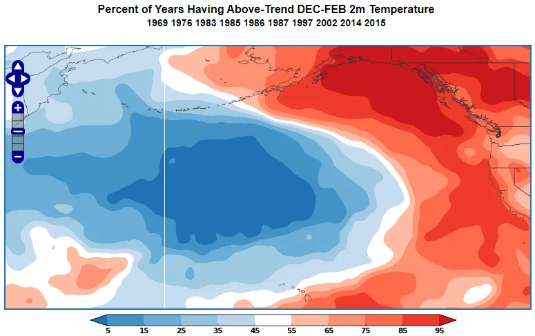
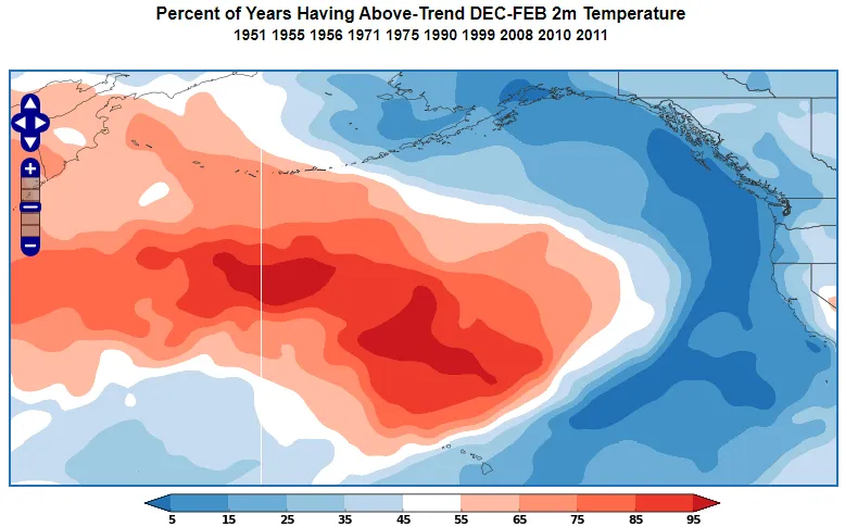
The PDO oscillates between positive and negative phases. The positive phase is characterized by cool SSTs north of Hawaii and warmer-than-normal sea surface temperatures along the western coast of North America. (Figure 1). The negative phase is a mirror image with warm ocean temperatures in the Central North Pacific and cooler than normal waters along the western coast of North America (Figure 2).

What is the Current Phase of the Pacific Decadal Oscillation (PDO)?
The current phase of the PDO is shown in Figure 3.
Impacts of the Positive Pacific Decadal Oscillation (PDO) Phase
Positive PDO Impacts – North American winter
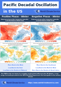
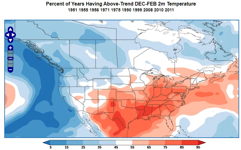
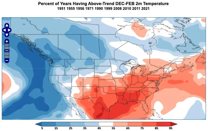
During the positive phase of the PDO in the northern hemisphere wintertime, the Southern and Eastern US is more likely to experience above normal temperatures, with below temperatures more likely in the West and Northwest (Figure 4).
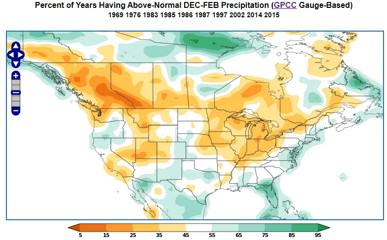
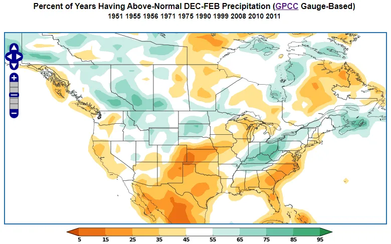
At the same time, the Northern Rockies and the Midwest are likely to be drier than normal, while Texas, the Gulf states, and the East are likely to be wetter than normal (Figure 5).
Impacts of the Pacific Decadal Oscillation Positive Phase on Asian Winters
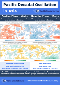
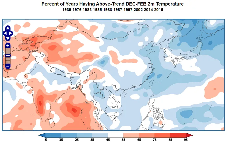
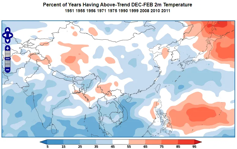
During the positive phase of the PDO in the northern hemisphere wintertime, much of Asia is usually cooler than normal, with above normal temperatures more likely over India (Figure 6).
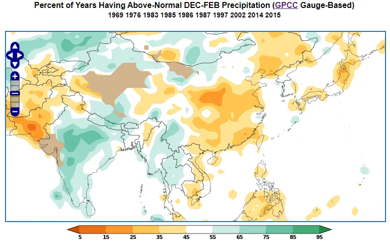
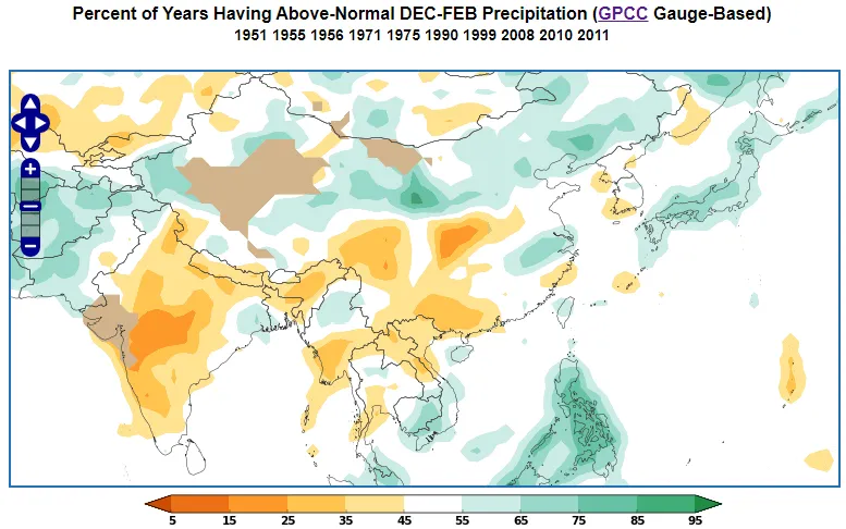
At the same time, China and Japan are likely to be drier than normal, while India often has a winter that is wetter than normal (Figure 7).
Negative Phase Impacts of the Pacific Decadal Oscillation
Negative Pacific Decadal Oscillation Impacts – North American Winter
During the negative phase of the PDO in wintertime, much of the lower 48 is usually warmer than normal. The West coast and the Northwest are normally colder than normal (Figure 8).
At the same time, many parts of the US will see drier than normal weather, but there are some notable exceptions. During a negative PDO, winter rainfall is usually above normal for the Ohio and Tennessee Valleys as well as the Northern Rockies and Plains (Figure 9).
Negative Pacific Decadal Oscillation Impacts – Asian Winter
During the negative phase of the PDO in the northern hemisphere wintertime, much of India and China is usually cooler than normal, But Japan has warmer than normal weather, especially in the North (Figure 10).
At the same time, Japan and Northwest China are usually wetter than normal, while Southwest China and much of India are usually wetter than normal (Figure 11).
The World Climate Service provides a powerful data mining system which enables users to quickly explore the Pacific Decadal Oscillation, and many other indices, by phase for each month of the year, showing impacts on all the major weather parameters all around the globe.
El Niño/Southern Oscillation (ENSO) and the PDO
Both ENSO and the Pacific decadal oscillation are important sea surface-based phenomena that influence weather conditions in the Pacific basin. There is extensive scientific literature reviewing the interactions between ENSO events and their relationship with the PDO, which is too extensive to cover here. We present in Figure 12 a well-known relationship between the two phenomena.
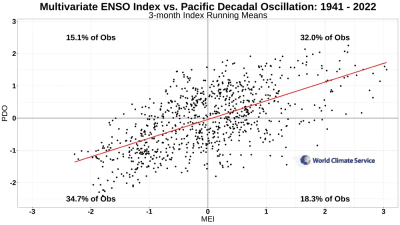
Figure 12 shows that when ENSO is in the El Niño phase (positive MEI), the PDO is also positive. This has occurred in 32% of the time since 1941. Likewise, when ENSO is in the La Niña phase (negative MEI) the PDO tends to be negative and has occurred approximately 35% of the time.
Pacific Decadal Oscillation and Long Range Forecasting
The Pacific Decadal Oscillation typically remains in a given phase for many years or even decades (Figure 13), but there can be some variation within a given decadal phase.
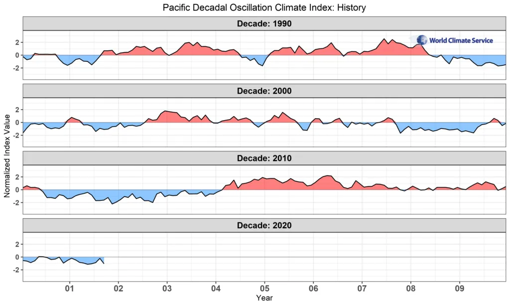
At the turn of the century, the PDO entered a long-term negative phase, but there was a positive hiatus between 2014 and 2019. Owing to the long-lasting phases of the PDO and their impact on Northern Hemisphere climates, this climate index is very useful for seasonal prediction.
Conclusion: Key takeaways about the PDO
The Pacific Decadal Oscillation is a cyclical variation of sea surface temperature anomalies over the North Pacific Ocean that influences weather patterns across large parts of Asia and North America.
The Pacific Decadal Oscillation phases persist for many years which makes the PDO a prime consideration in seasonal forecasting.