What does ENSO stand for?
ENSO is an acronym for the El Niño/Southern Oscillation, a phenomenon of tropical Pacific Ocean sea surface temperature variations that drive global climate variability. The ENSO cycles are the most significant and impactful climate cycle on Planet Earth and have important implications for long-range forecasting. ENSO events originate over the equatorial Pacific Ocean but also affect climate conditions and society in general around the globe. Pacific sea-surface temperatures oscillate back and forth between relatively warm (El Niño) and cool (La Niña) phases in an irregular cycle every few years.
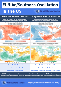
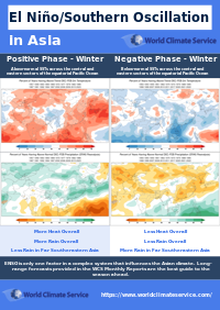
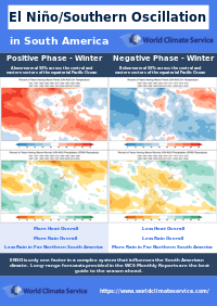
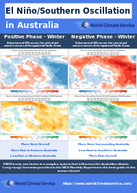
Each phase, which persists for months and even years, imposes characteristic weather regimes on parts of the planet. This makes ENSO a valuable climate index in a long-range forecaster’s toolkit. Check out and click on the El Niño/Southern Oscillation (ENSO) quick summary PDFs for the:
What is the Current Value of El Niño/Southern Oscillation (ENSO)?
The current value of ENSO is shown in Figure 1.
ENSO Sea Surface Temperatures
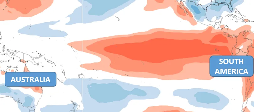
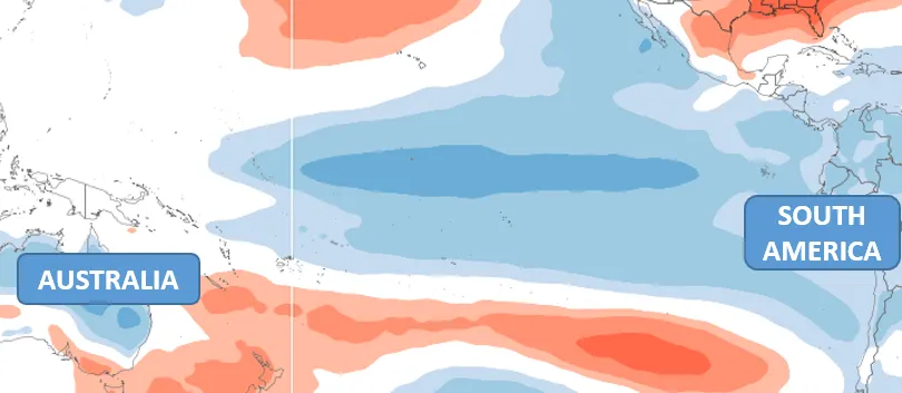
The El Niño part of ENSO refers to the Sea Surface Temperatures (SST) across the central and eastern sectors of the equatorial Pacific Ocean. More specifically, El Niño refers to the anomaly of the SSTs, which cycles between warmer than normal, and cooler than normal. The warm phase of ENSO is called El Niño (Figure 2), while the cool phase is called La Niña (Figure 2).
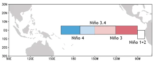
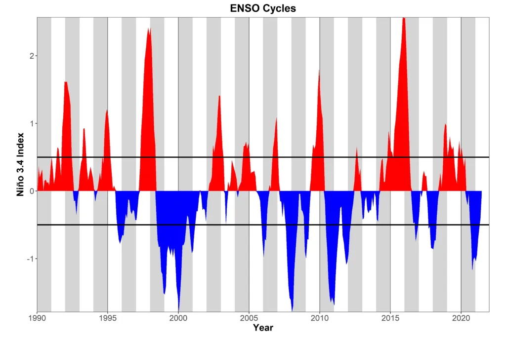
The equatorial Pacific is split into Niño regions for the purposes of monitoring changes in seas surface temperature (Figure 4). The Niño 3.4 region is used to define ENSO. When the Niño 3.4 region has an average SST at or above +0.5°C on the Oceanic Niño Index (ONI), then ENSO is deemed to be in the El Niño phase. Likewise, when the Niño 3.4 region SST is at or below -0.5°C on the ONI, then ENSO is deemed to be in the La Niña phase.
An ENSO event is officially declared after the ONI anomaly persists for three consecutive 3-month running means, but this stipulation is of little concern to forecasters.

ENSO Impact on the Atmosphere
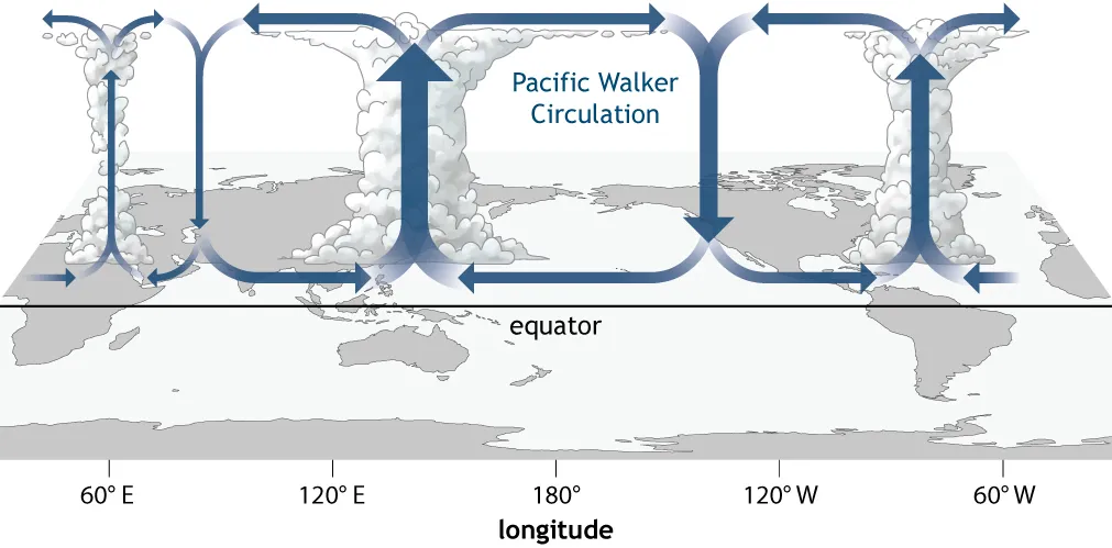
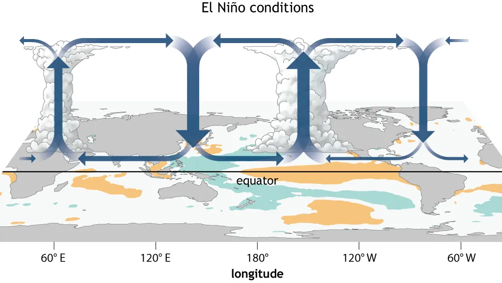
The second part of ENSO, Southern Oscillation, refers to the atmospheric response to the underlying SSTs. The Southern Oscillation Index (SOI) describes the mean sea level pressure difference between Darwin, Australia and Tahiti. A negative (positive) value typically occurs during El Niño (La Niña) phases. The SOI is only one component of a large atmospheric circulation known as the Walker Cell.
The Walker Cell is a global-scale convective circulation driven by warm SSTs in the tropics (Figure 5). The circulation is modified as the underlying SSTs change. A notable component of the Walker Cell is the easterly flow at the surface across the equatorial Pacific. This flow strengthens during La Niña episodes and weakens (or even reverses) during El Niño.
For the most part, the La Niña phase tends to super-charge the usual Walker Cell, but an El Niño phase results in wholesale changes to the pattern because the warmer-than-normal SSTs cause deep atmospheric convection which impacts the circulation across the entire tropical Pacific Ocean (Figure 6).
Characteristics of the El Niño/Southern Oscillation
ENSO displays an irregular cycle with a period of 2 to 7 years (Figure 7). Typically, El Niño lasts 9-12 months, while La Niña can persist for 1-3 years, often spanning two winters. Both phases tend to peak during the boreal winter and then become weaker during the summer.
Global Climate Weather Condition Impacts
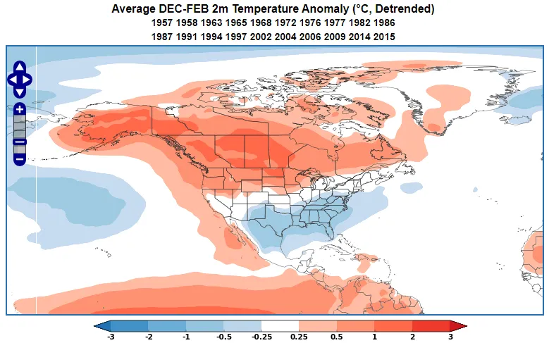
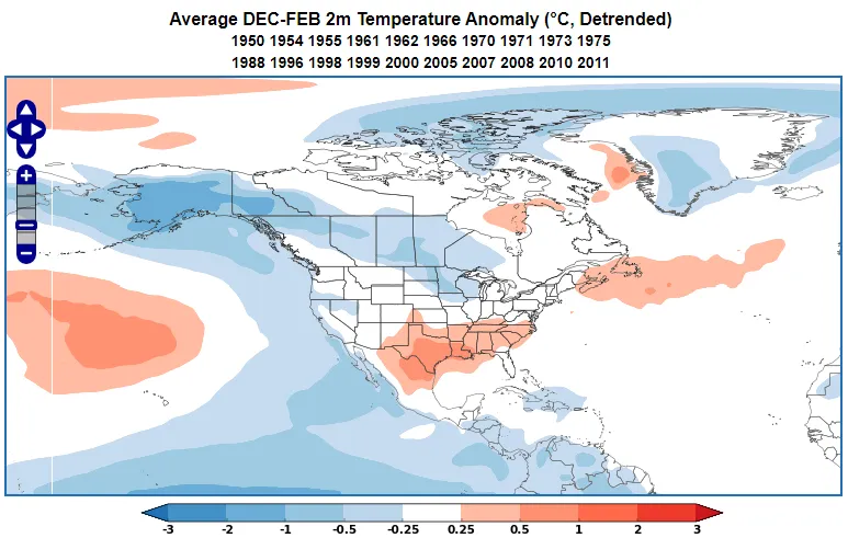
World Climate Service users can easily explore the global impacts of ENSO using the WCS Climate Index Analogs page. During an El Niño, we see the characteristic warm north / cold south pattern across the lower 48 in winter (Figure 8), while the opposite is true of La Niña winters (Figure 9).
El Niño/Southern Oscillation and Long-range Forecasting
As ENSO phases tend to persist for many months and to affect weather conditions globally, it has become the foundation of long-range forecasting. A positive or negative ENSO phase is often the starting point to a long-range forecast.
Dynamical models are remarkably skillful at forecasting ENSO many months ahead so when ENSO events are expected, forecasters will have a good idea as to what to expect in the coming months.
The most uncertain times are in summer when ENSO naturally weakens, and also during transition phases. Forecasts of the ENSO cycles themselves are most uncertain in the Northern Hemisphere spring. That phenomena is called the spring predictability barrier. Dynamical computer models usually manage to predict which way ENSO will go, but not always. There are also occasions where ENSO remains in an indistinct neutral phase for extended periods.
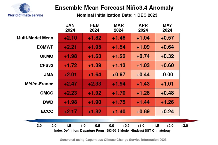
The World Climate Service presents subscribers with the calibrated seasonal model forecasts of ENSO from all of the world’s leading global models (Figure 10). In this example, there is an overwhelming consensus for a La Niña episode in the coming months.
ENSO: Conclusion
The ENSO cycle originates in the tropical Pacific and is the most significant climate driver on the Earth. The state of ENSO is usually known, and this sets forecast expectations for large parts of the tropics and subtropics for many months ahead. Dynamical computer models usually predict ENSO well, but there are occasional periods of uncertainty.