One of the terms that is commonly encountered in seasonal forecast discussions is the “ENSO spring barrier”, or “spring predictability barrier”. It’s often used to highlight the uncertainty in the outlook for ENSO (the El Niño – Southern Oscillation) in the first half of the year, and it conveys the general idea that ENSO forecasts are intrinsically more uncertain, or less skillful, in connection with Northern Hemisphere spring.
But how exactly does the ENSO spring barrier work? Does it mean that the future of ENSO is completely uncertain until spring has passed? How bad is the situation? At what time of year should we start distrusting ENSO forecasts, and when can we start to believe them again?
The most common understanding of the ENSO spring barrier seems to be that ENSO forecast skill is significantly reduced during the spring, and any time a forecast is made for the other side of spring, because of the tendency for the ENSO phase to shift as El Niño and La Niña episodes decay after their usual winter peak. For an example of this notion, see the following blog post from NOAA:
The academic literature on ENSO forecasting often reflects the same idea; for example, “…models have problems in predicting boreal winter tropical Pacific sea surface temperature (SST) when forecasts start in boreal spring (February–May). This is called the spring predictability barrier” (Lai et al. 2018). Similarly, “…errors have the largest values and the fastest growth rates initialized before and during the NH spring” (Zheng and Zhu 2010).

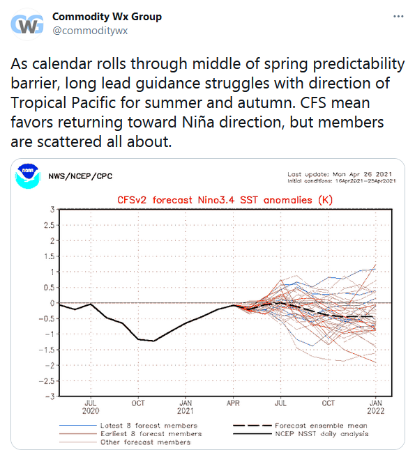
The clear implication of this perspective is that ENSO forecasts are of dubious value until prediction schemes are initialized with new data after the spring season, i.e. in early summer. This is also the paradigm that seems to govern many long-range forecasters; for example, the following tweet was issued on April 26 by industry leader Commodity Weather Group:
Examining the Data
To assess whether this common perspective is justified, it’s useful to look at some historical ENSO data. First, consider one of the simplest possible forecast schemes for ENSO SSTs: the “anomaly persistence” forecast. Here we simply predict that the SST departure from normal will be the same in all future months as in the current month; for example, if the SST anomaly is currently +2°C, we expect the SST to remain 2°C above the seasonal normal indefinitely.
The figure below shows the skill, as measured by the correlation coefficient, of these simple forecasts. (Note that the horizontal axis extends over more than one year, to highlight the annual cycle.) Anomaly persistence works extremely well (R>0.9) for 5-month forecasts issued in late summer and extending into winter, and also for autumn and winter forecasts that target months prior to late spring. However, the forecasts run into real trouble when they predict for May, and the problem becomes much worse in June and beyond, so that persistence is completely unable to predict where ENSO will be on the other side of spring. It’s a spring predictability barrier.
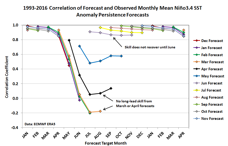
It’s clear from these results that simple persistence forecasts do line up with the common understanding of the ENSO spring barrier; anticipating ENSO on the other side of spring is intrinsically very difficult. It’s not until spring is completely over (June) that skill is largely recovered for this simple forecast scheme.
Copernicus Models
Now let’s see if modern dynamical model forecasts behave the same way. To address this, I’ve taken hindcast data from five of the leading models provided by the EU’s Copernicus Climate Change Service (C3S). After computing the ensemble mean of each model separately, and then taking the multi-model mean, the skill is calculated in just the same way as the persistence forecasts above. (But note the different scale on the vertical axis.)
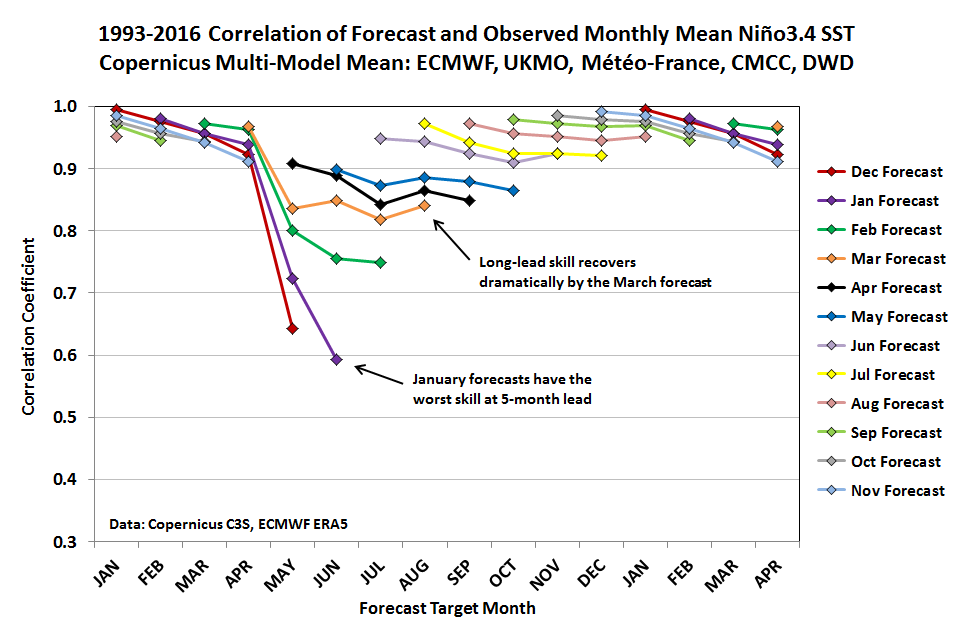
Superficially, the results look quite similar to the persistence analysis, with a significant drop-off in skill when May and June are the target months. However, a closer look reveals that the Copernicus models actually behave quite differently around the ENSO spring barrier. Notice in particular that the worst skill (R~0.6) is found in the January forecasts for June.
The February forecasts for June are better (R~0.75), and the skill recovery continues in the March forecasts (R~0.85 for June). Unlike the persistence forecasts, the Copernicus models are able to predict summer ENSO with good skill by the time spring is underway; in other words, the ENSO spring barrier is a problem for forecasts issued in winter, but much less so for forecasts issued in spring itself.
With this knowledge, we can answer the questions posed at the beginning of this post. When we’re talking about modern dynamical model forecasts – which are usually the focus of any seasonal ENSO outlook – the spring barrier is a major hindrance during winter when looking ahead to summer or beyond. Summer forecasts issued in mid-winter aren’t worthless, but a correlation of R~0.6 corresponds to only about a third of the variance being explained.
However, as winter ends and spring begins, the models quickly recover their long-lead skill, and as early as March the spring barrier is greatly reduced. In practical terms, we should distrust any forecast issued in winter or earlier that looks beyond spring into summer or beyond. But the forecasts are considerably more accurate by March, and each month after that improves the skill incrementally up to the autumn peak in long-lead skill.
The ENSO Spring Barrier in Practice
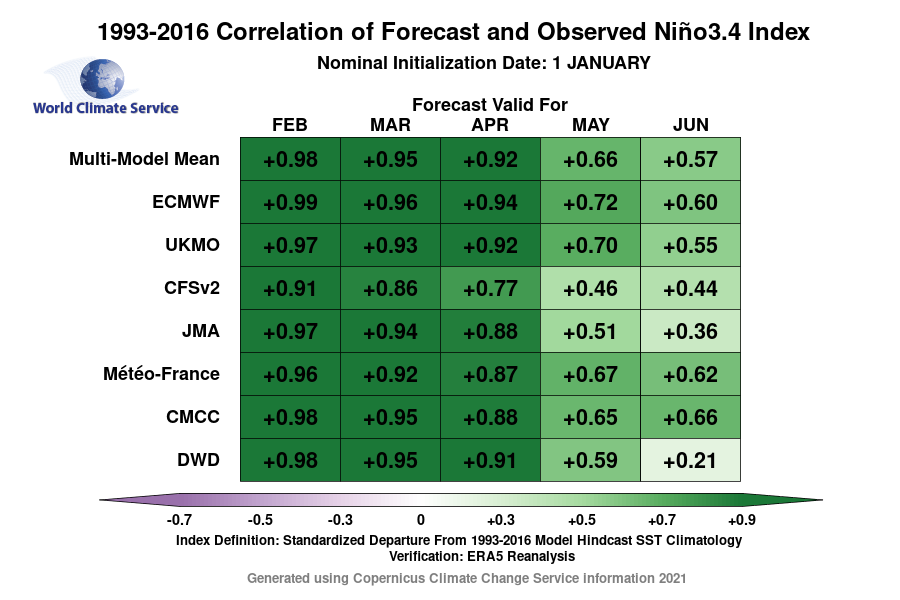
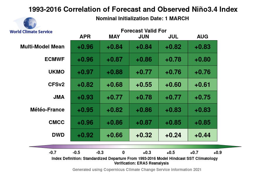
To further illustrate seasonal ENSO forecast skill, the figures below show monthly correlation coefficients for several Copernicus models; these are operational graphics available to customers on the World Climate Service seasonal forecast portal. The first table shows skill for forecasts issued in January, and the second graphic pertains to March forecasts. Conventional wisdom would suggest that March forecasts are still badly hampered by the ENSO spring barrier, but in fact, the skill improves significantly between January and March at a 5-month lead time – and the same thing happens for all the models.
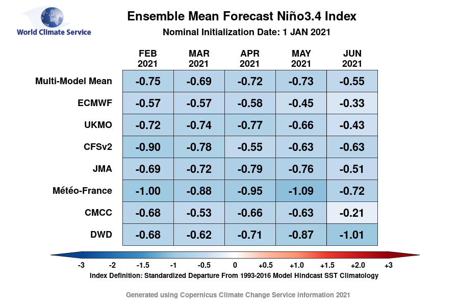
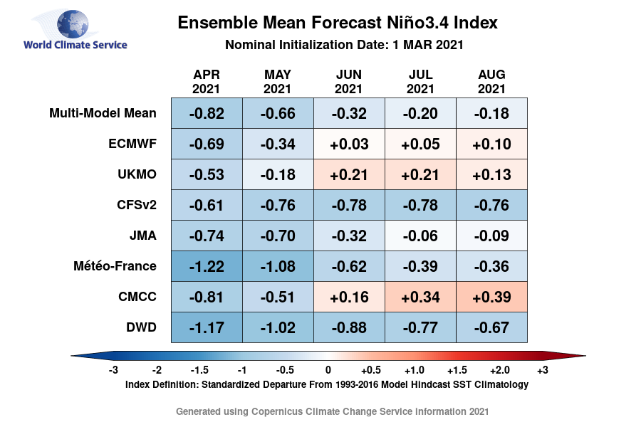
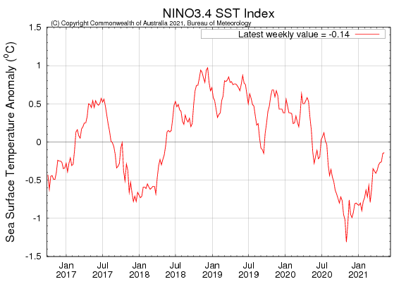
The Niño3.4 forecasts issued in January and March 2021 are shown below. The January forecasts suggested that only modest warming was likely by June, with ENSO remaining near the -0.5°C anomaly threshold of La Niña in early summer. But by March, the forecasts had shifted significantly towards a warmer solution, with the multi-model mean indicating only a marginal negative SST anomaly in June and beyond. The third figure below shows that Niño3.4 SSTs have indeed warmed quite rapidly, and are well above -0.5°C already as of mid-May.
In summary, the ENSO spring barrier is a real problem and a major hindrance to long-lead seasonal ENSO forecasts that seek to look beyond spring. But the modern generation of dynamical models is remarkably good at surmounting the barrier, and this occurs earlier in the year than is commonly understood. By March, the barrier is significantly ameliorated; and seasonal forecasters should take advantage of this fact to recover their confidence even as winter ends.
References
Lai, A. W.-C., M. Herzog, and H.-F. Graf, 2018: ENSO Forecasts near the Spring Predictability Barrier and Possible Reasons for the Recently Reduced Predictability. J. Climate, 31, 815-838. https://doi.org/10.1175/JCLI-D-17-0180.1
Zheng, F., and J. Zhu, 2010: Spring predictability barrier of ENSO events from the perspective of an ensemble prediction system. Global and Planetary Change, 72, 108-117. https://doi.org/10.1016/j.gloplacha.2010.01.021