Sea Surface Temperatures: Why Are They Important in Long-Range Forecasting?
This article discusses the vital role that sea surface temperatures play in driving the global climate. We also explain why sea surface temperatures are particularly useful in long-range forecasting.


Sea Surface Temperatures: Introduction
The Earth’s atmosphere exchanges heat, water, and momentum with the Earth’s surface continuously worldwide. So, if you want to know the weather, you absolutely need to know about the surface of the Earth. When you then consider that more than 70 percent of the Earth’s surface is the ocean, you soon realize that the sea surface must exert a huge influence on the atmosphere.
Sea surface temperatures (SSTs) are crucially important in weather and climate forecasting. Unfortunately, knowledge of sea surface temperatures was, for a very long time, difficult to come by. Oceans are vast and very remote, so for most of the last 400 years, the only source of this information was from the few and scattered observations made on ships.
An enormous technological breakthrough came in the 1970s when weather satellites started routinely monitoring the Earth and atmosphere. Satellites have the considerable advantage of being able to “see” virtually the entire globe, no matter how remote a location may be.
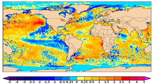
These days SSTs are continuously monitored in great detail across virtually the whole world, and this data forms a vital ingredient of modern-day numerical weather prediction (NWP). As with many other weather parameters, SSTs can be expressed as an anomaly from a long-term average, and this context provides critical insight for climate diagnosis and prediction.
Sea Surface Temperatures: Climate Indices
As well as being a key source of information for dynamical NWP models, SSTs also provide us with valuable information about the state of the climate. Climate scientists have identified numerous large-scale climate drivers in various parts of the world by studying the history of SSTs and associated climate variations. Knowing where these SST drivers are in their cycles and where they will be in the future provides valuable information about past, current, and future weather. Climate indices have been constructed to describe the position of a given driver within its cycle.
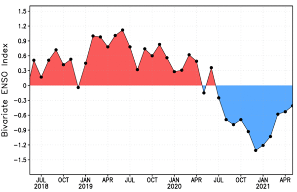
The most influential and well-known SST climate index is the El Niño/Southern Oscillation (ENSO). ENSO is an irregular cycle of warmer and cooler SSTs that occur over the equatorial Pacific Ocean. As ENSO SSTs flip between warm and cool, vast areas of the globe see characteristic changes in their climate, which can persist anywhere from a few months to three years.
Other large-scale SST cycles which have important impacts on climate include the Indian Ocean Dipole, the Atlantic Multi-Decadal Oscillation, the Pacific Decadal Oscillation, and the Southern Oscillation Index – all of which can be monitored via the World Climate Service climate indices page.
Local Impacts and Sea Surface Temperatures
In addition to large-scale climate drivers, SSTs can also be very influential at the local level. For coastal districts, the SST anomalies directly impact the temperature of the air. For example, if the waters off the California coast are cooler than normal, then any air flowing from the ocean will tend to be cooler than normal.
Another example of sea surface temperatures impacting weather is found in the areas in which tropical cyclones (TCs) can form. Warm SSTs make TCs more likely to develop, and once developed, higher SSTs can provide added fuel, making the storm stronger than it might otherwise be. The same is true in reverse; if the SSTs are cooler than normal, this can inhibit initialization and hamper strengthening.
Other examples of SSTs influencing weather patterns can be found in the mid-latitudes. Cool SST anomalies contribute to the development of extratropical cyclones with a lead time of a few days to a week.
Changes in Sea Surface Temperatures
Many mechanisms change SSTs. One mechanism is a persistent wind in a specific direction. The wind “blows away” a shallow warm layer of water, which is replaced by cooler waters from below. Thus, the water moved by the wind may be warmer or cooler than neighboring waters, and the SSTs may change at the new location.
Yet another mechanism may be the bodily upwelling of cooler waters from the deep ocean, which is part of what is called the Global Conveyor Belt – a generally stable worldwide system of ocean currents. The ever-changing SSTs can be monitored via the World Climate Service SST maps page.
Sea Surface Temperatures: Long Range Weather Forecasting
As SST anomalies often persist for weeks, months, or even years, they become a valuable source of information for long-range weather forecasts. Small-scale weather features are essential for short to medium-range weather forecasting, but their influence is soon swamped by the noise generated in the chaos of weather systems. SSTs can retain information and influence conditions over much longer time periods and thus provide invaluable input into subseasonal and seasonal forecasts. By monitoring SST changes, we can also anticipate future changes to large-scale climate drivers such as ENSO.
Conclusion
Sea surface temperatures are an important driver of global weather. In some parts of the world, SSTs exhibit long period cycles that can drive long-lasting climate regimes. However, SSTs can also strongly affect local weather on shorter time scales. Sea Surface Temperatures, therefore, provide a valuable ingredient to long-range weather forecasting and monitoring the state of SSTs, and their changes play a vital role in weather and climate forecasting.