The French Open tennis tournament is normally held in June, but in 2020 it occurred later in the year than normal because of the COVID pandemic. The temperatures during the event were much colder than players were used to. According to CNN, Victoria Azarenka, a former #1 in the World ranked tennis player, had to walk off the court during a break in play because the temperatures were so low. The world’s best tennis players had converged on Paris for a cold September tournament but it’s likely that none of them were aware it was because of a negative East Atlantic – Western Russia climate pattern.
In this article, we investigate the East Atlantic – Western Russia climate pattern (often referred to as simply the EA-WR): what it is, how it impacts the weather, and how it’s used in long-range forecasting.

What is the East Atlantic – Western Russia Pattern (EA-WR)?
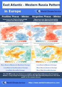
Along with the North Atlantic Oscillation, and the SCAND, the East Atlantic – Western Russia pattern (EA-WR) is one of the most important atmospheric phenomena (or teleconnections) that shapes the flow pattern over Europe. Its index is one of the important climate indices. Check out and click on the East Atlantic – Western Russia pattern (EA-WR) quick summary PDFs for:
The EA-WR can influence the weather across the whole of Europe with characteristic patterns in evidence at different times of the year. The EA-WR dipped strongly negative at the end of September 2020, which brought a chill to much of France.
The World Climate Service provides a powerful data mining system that enables users to quickly explore the East Atlantic – Western Russia pattern, and many other climate indices, by phase for each month of the year, showing impacts on all the major weather variables right around the globe.
What is the Current Value of the East Atlantic – Western Russia (EAWR) Pattern?
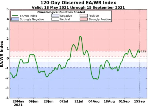
The current value of the EAWR is displayed in Figure 2.

East Atlantic – Western Russia: Positive Phase
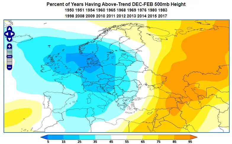
The EA-WR is driven by a pressure pattern over Western Russia forming a dipole pattern with the pressure over the Western Europe. Figure 3 shows a positive EA-WR in winter occurring when low pressure resides over Western Russia and high pressure over Western Europe.
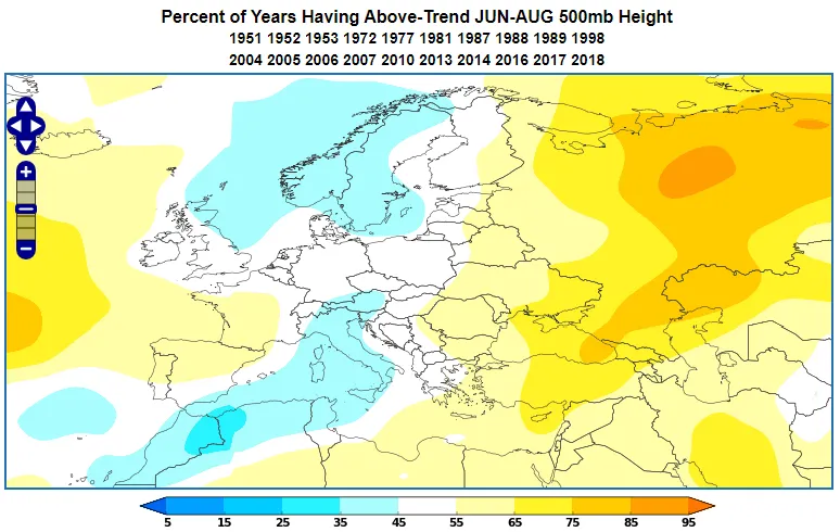
A positive EA-WR in summer (Figure 4) displays a similar set up to the winter pattern with high pressure in the West and low pressure over Russia, but the whole pattern is slightly rotated; low pressure extends farther into the Mediterranean and high pressure extends into Sweden, Finland and the Baltic States.
Impact 1: East Atlantic – Western Russia: Positive Phase in winter
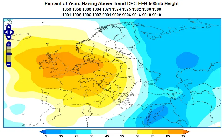
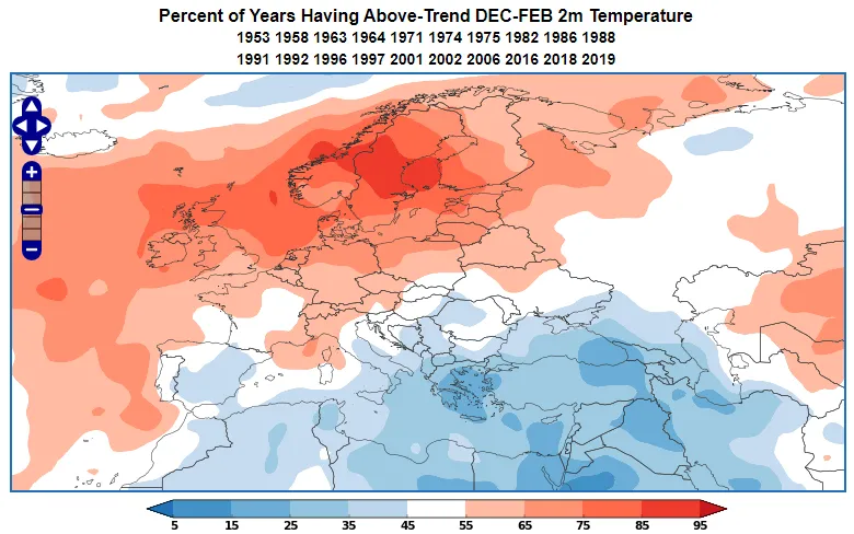
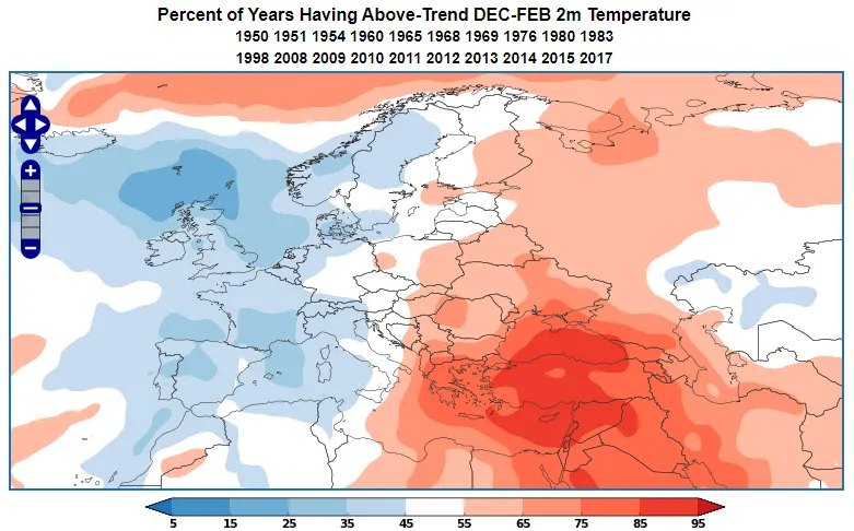
During the positive phase of the EA-WR Index in the wintertime, much of Northern Europe is likely to be warmer than normal, especially Scandinavia, but the Mediterranean and particularly Turkey, are usually cooler than normal (Figure 5).
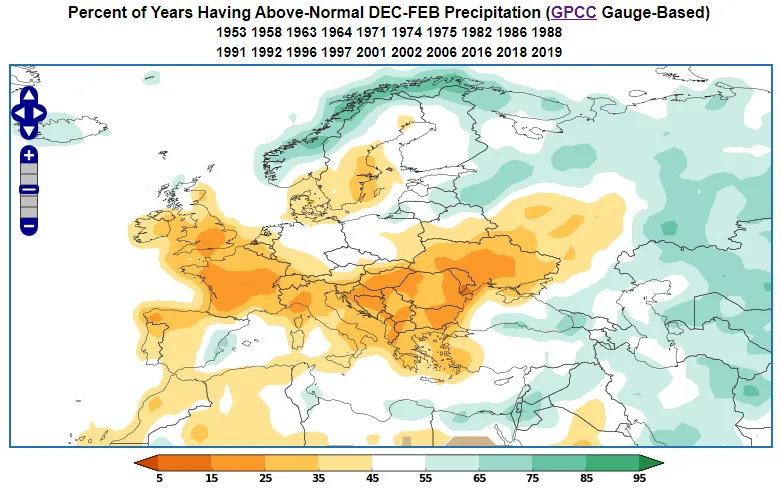
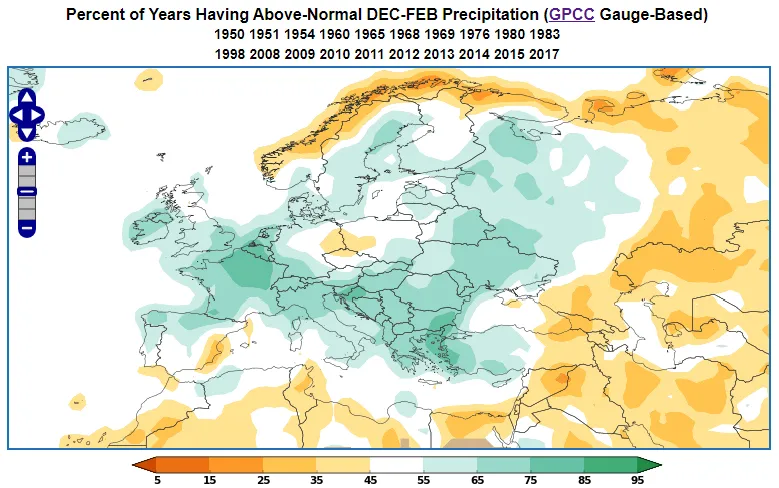
At the same time, much of Europe is likely to be drier than normal. The positive EA-WR usually brings relatively wet winters to Norway, the Baltic States and Eastern Turkey (Figure 6).
Impact 2: East Atlantic – Western Russia: Positive Phase in summer
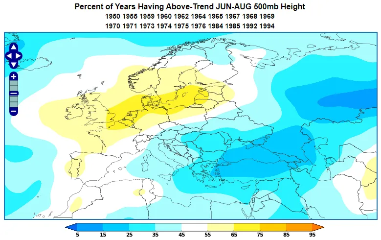
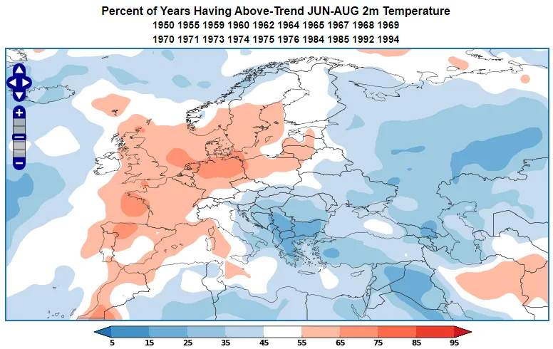
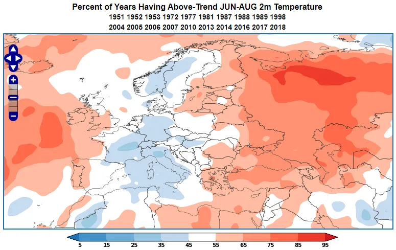
When the summer EA-WR Index is positive (Figure 7), there is a tendency toward higher than normal temperatures across Western Europe and the Baltic. At the same time, Western Russia and Southeastern Europe are more likely to be cooler than normal.
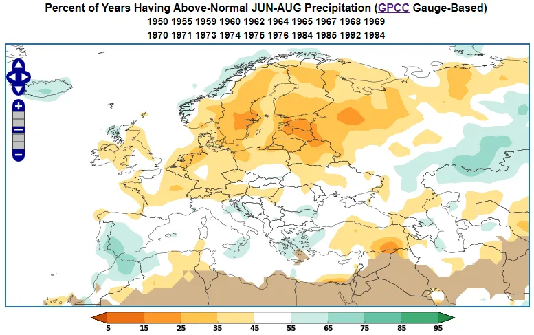
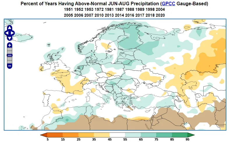
The positive EA-WR usually brings a dry summer to much of Central and Northern Europe. Parts of Southern Europe can be wetter than normal, particularly over Southern Iberia (Figure 8).
East Atlantic – Western Russia: Negative Phase
The negative phase of the EA-WR is more or less a mirror image of the positive phase, with high pressure resident over Western Russia (Figure 9), and low pressure affecting much of Central and Northwestern Europe. See how the Atlantic Ridge weather regime best matches with a negative East Atlantic-Western Russia pattern here!
In the summer high pressure still features prominently over Western Russia, but low pressure in the west is less extensive, being confined to the Central Mediterranean and the far Northwest (Figure 10).
Impact 3: East Atlantic – Western Russia: Negative Phase in winter
During the negative phase of the EA-WR index in wintertime, much of Western Europe is likely to be colder than normal. At the same time, much of Western Russia and Southeastern Europe is more likely to be warmer than normal (Figure 11).
Meanwhile the negative EA-WR in winter usually brings surplus rainfall to most of Europe. The fringes of Europe are usually drier than normal, as is a small region of Eastern Germany and Western Poland (Figure 12).
Impact 4: East Atlantic – Western Russia: Negative Phase in summer
In summertime when the EA-WR is negative we expect cooler than normal weather across the central slice of the continent. At the same time, we are more likely to find above normal temperatures over the far west of Europe, far east of Europe and all of Western Russia (Figure 13).
In terms of rainfall, the negative East Atlantic – Western Russia in summer is likely to bring wetter than normal weather to much of Northern and Southeastern Europe, while parts of Central Europe, Southern Iberia and Southwestern Russia are liable to be drier than normal (Figure 14).
EA-WR Forecasts: Long Range Forecasting
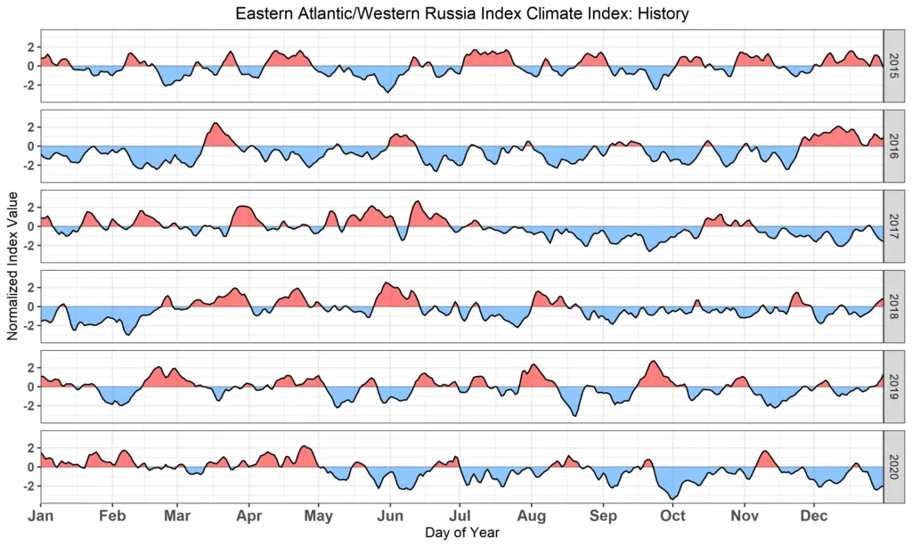
The East Atlantic – Western Russia pattern typically remains in a given phase anywhere from a few days, to a few weeks. Thus the EA-WR is very much a subseasonal climate index (as opposed to a longer-lasting seasonal climate index such as ENSO). Figure 15 shows the variation of the EA-WR over a period of a few months.
Occasionally the subseasonal models will latch on to a high probability of one phase or the other with a 2 or 3 week lead time. If we see cross-model support, then we can start to think about what typically happens for that phase of the EA-WR at that particular time of year.
EA-WR Forecasts: Included in the World Climate Service
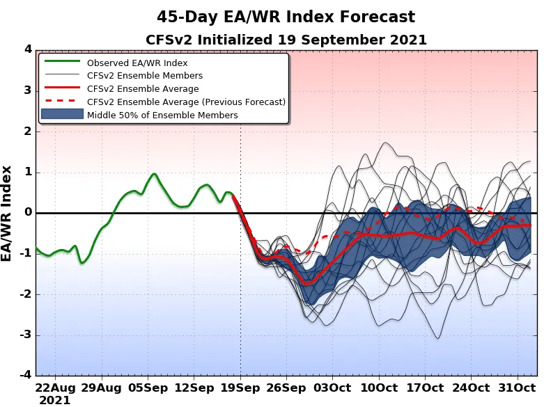
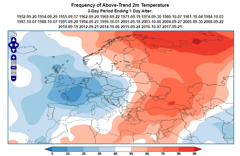
Figure 16 shows an example of an East Atlantic – Western Russia index forecast. We see that the EA-WR is likely to be negative at the start of October. The WCS analog system allows users to instantly generate an analog map for various weather variables.
The WCS analog system finds dates in the past when the EA-WR was negative at the same time of year. The temperature anomalies that occurred on those dates are then aggregated to produce an analog map (Figure 17).
We can see that typically when the EA-WR is negative at the start of October, then much of Central and Western Europe is likely to be cooler than normal, while large parts of Eastern Europe and Western Russia are likely to be warmer than normal.
The East Atlantic – Western Russia Pattern – Concluding Remarks
The East Atlantic – Western Russia climate index is a measure of a pressure dipole that exists between Western Russia and Western Europe that influences the weather across large swaths of the continent. The EA-WR is a subseasonal phenomenon that is relatively choppy and rarely persists in one phase for more than a week or two.
The East Atlantic – Western Russia pattern is an important consideration in subseasonal forecasting as it creates characteristic weather patterns across much of Europe that change with time of year.