It isn’t easy to comprehend, but the stratospheric polar vortex (SPV) can suddenly and significantly impact winter weather down here on the Earth’s surface. For a prime example, take the 2018 “Beast from East” event in Europe that produced record-breaking cold weather across a large part of Europe (Figure 1).
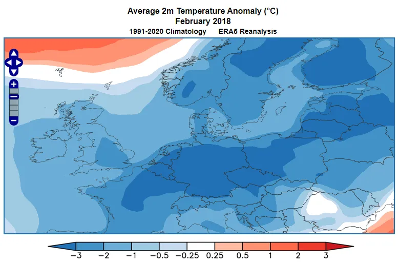
An analysis of the “Beast from East” event concluded their “study demonstrates that the movement of the SPV is a key linkage in late winter subarctic and northern mid-latitude extreme weather events”.
Understanding the stratospheric polar vortex is critical for ensuring long-range forecast predictability, particularly in the Northern Hemisphere mid-latitudes. In this article, we investigate the Stratospheric Polar Vortex, what it is, how it impacts the weather, and what it means for subseasonal weather forecasting.

The Stratospheric Polar Vortex – Introduction
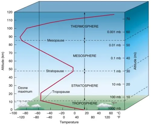
The stratosphere is the layer of the atmosphere 7-30 miles (12-48km) above the surface of the Earth (see Figure 2). It lies above the troposphere, the lowest layer containing virtually all of the atmospheric water vapor and the weather we experience every day. The stratospheric air may be clear and very thin, but it can have a surprisingly strong impact on the winter weather across northern latitudes.
The Stratospheric Polar Vortex – The Vortex
In the Northern Hemisphere winter half of the year, the air within the stratosphere above the Arctic gently spins west to east, or counter-clockwise, as we look down on the North Pole. This vortex develops in the fall, peaks in the winter, and then dissipates during the spring.
When the vortex is strong, it spins faster than normal, in a stable procession, perhaps with some slow and inconsequential waves. Sometimes the vortex is weak, which, like a slowly spinning top, causes the vortex to teeter and be more susceptible to collapse.
The vortex occasionally collapses suddenly. When it does, the vortex temporarily spins with a retrograde, or clockwise, motion. This event is called a sudden stratospheric warming (SSW) as the frigid stratospheric air within the core of the vortex sinks, becomes compressed, and causes stratospheric temperature to temporarily rise by as much as 50°C.
The Stratospheric Polar Vortex – Strong and Weak Vortex Impacts
When the vortex is strong, it spins faster than normal, with a stronger westerly wind. This type of vortex is compact and relatively stable. Below a strong SPV, the tropospheric polar jet stream tends to be stronger, thus contributing to a positive Arctic Oscillation. A positive AO leads to mild weather on average across northern latitudes.
When the vortex is weaker than normal, the westerly flow is relatively slow and tends to meander. Below a weak SPV, the tropospheric polar jet stream is not strongly influenced from above and tends to respond primarily to tropospheric forcing. A negative Arctic Oscillation is more likely during a weak SPV event – which means a higher risk of cooler than normal weather across much of the Northern Hemisphere mid-latitudes.
The Stratospheric Polar Vortex – Mid-Winter Collapse
Each spring the stratospheric polar vortex will dissipate – sometimes this is gradual, and sometimes the vortex collapses in an event known as a “final warming”. The demise of the SPV in spring does not usually significantly affect the weather within the troposphere below.
In one out of every two winters, the SPV collapses in mid-winter (any time from November to March). When this happens, then there can be significant consequences for the weather across mid-latitudes.
The SPV is deemed to have collapsed when the wind at 10 hPa becomes easterly. A list of sudden stratospheric warming events since 1958 can be found here.
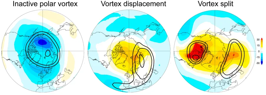
The collapse of the SPV can result in two distinct configurations of the vortex (Figure 3). The first is a displacement, and the second is a split. A split is considered to be more impactful on mid-latitude weather conditions.
Even today, the mechanisms which trigger the collapse of the SPV are not well understood and remain the subject of scientific investigation.
The Stratospheric Polar Vortex – Mid-Winter Collapse Impacts
The sinking air within a collapsed SPV causes pressure to increase. This region of high pressure quickly ripples down, not just into the troposphere but right down to Earth’s surface. High pressure over the Arctic (negative Arctic Oscillation) allows cold polar air masses to flow into the mid-latitudes.
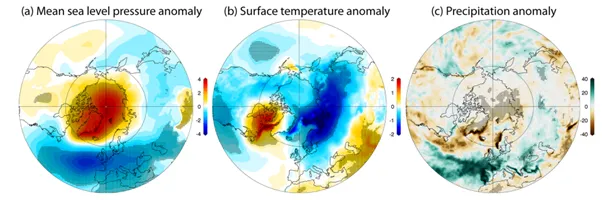
In Figure 5 we see a strongly negative Arctic Oscillation ((a) high pressure over the Arctic) leading to colder than normal temperatures (b) across much of the mid-latitudes. There is also a strong change in rainfall distribution (c) over Western Europe as the storm track is forced farther south.
The weather over mid-latitudes can be impacted for up to 90 days following a collapse of the SPV, but it is important to note that around 40 per cent of collapsed SPV events do not result in significant spells of colder weather over the mid-latitudes.
Predicting the Stratospheric Polar Vortex
Sudden stratospheric warmings are usually well predicted by the dynamical models that have a good representation of the stratosphere. Warmings at 10 mb are often detected with lead times of up to 14 days ahead. Subsequent forecasts will often show the anomalously warm air descending towards the troposphere, and the pressure fields will show whether the event is likely to be in the form of a displacement or split.
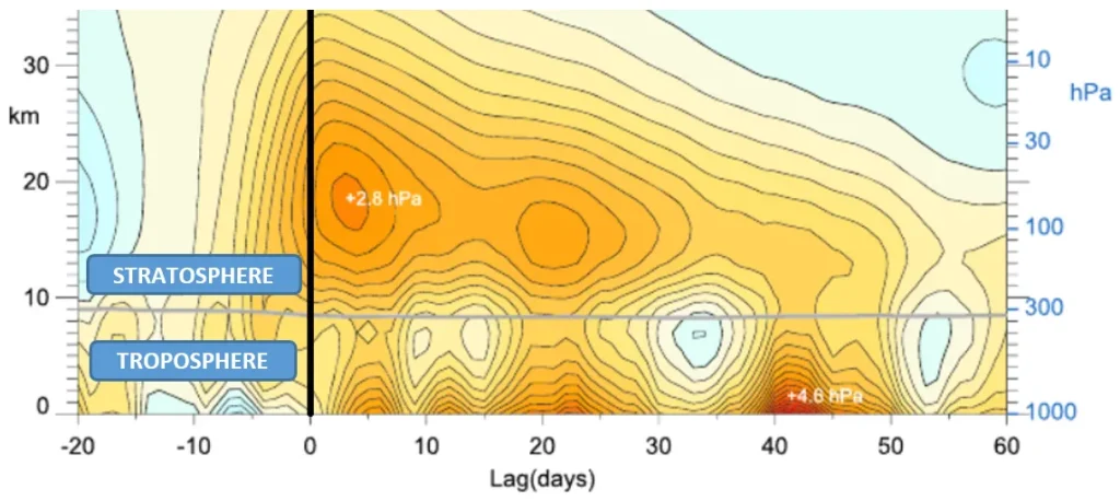
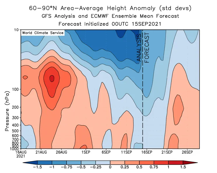
The World Climate Service includes information to help predict the SPV and the chances of a sudden stratospheric warming. For example, the polar cap height (similar to pressure) anomaly forecasts show a cross-section over the Arctic (Figure 6). The stratosphere lies above approximately 300 hPa, with the troposphere below.
As shown in Figure 6, negative height anomalies (blues) within the stratosphere (above 300 hPa) indicate a strong SPV, whereas positive height anomalies (reds) indicate a weak SPV. Thus, a sudden warming event will show up as a rapid onset of red shades within the forecast near the top of the stratosphere. Over the coming days and weeks the red shades will be seen to descend into the troposphere (below 300 hPa).
Once the positive heights (high pressure) appear in the troposphere we see the Arctic Oscillation turn sharply negative, and the mid-latitudes are then much more likely to experience cold weather.
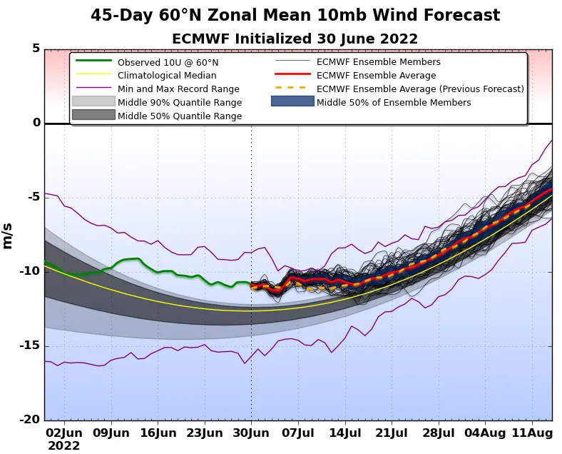
In addition, the World Climate Service suite of predicted subseasonal climate indices includes forecasts of the zonal mean 10 mb wind speeds (Figure 7) and an SPV index forecast (Figure 8). These are two views of essentially the same phenomenon.
The 10 mb wind speed forecast at 60N shows absolute values in the context of climatology, making it easy for subscribers to see if the stratospheric polar vortex is anomalously strong or weak. An alternative view is provided by the SPV Index, which is a standardized view of Northern Hemisphere high latitude wind speeds.
It is always prudent to wait until the stratospheric warming event has occurred to see exactly which type of vortex collapse transpires. Although dynamical models may predict the collapse of the SPV well, they may not always forecast the subsequent evolution of the troposphere well. The forecaster will be mindful of the propensity for a negative Arctic Oscillation to develop and the associated impacts of that pattern.
A sudden stratospheric warming occurred in the first week of January 2021. The World Climate Service’s Richard James describes the collapse of the SPV in a recent blog post. In this fascinating post, Richard discusses how this event in the stratosphere could be used in combination with the Madden-Julian Oscillation forecast to anticipate the surface weather that could be expected to manifest in the coming weeks, and evaluate the dynamical temperature forecasts that were available at that time.
The Stratospheric Polar Vortex – Conclusion
Although the Stratospheric Polar Vortex spins high above the Arctic during the winter half of the year, it can have dramatic ramifications on the winter weather conditions at Earth’s surface. A strong SPV makes a positive Arctic Oscillation more likely.
The stratospheric polar vortex collapses suddenly every other winter on average. A mid-winter warming of the SPV makes a negative AO more likely over the subsequent 90 days, which brings a long-lived cold threat to the mid-latitudes.
The significant impacts of a sudden stratospheric warming mean long-range forecasts of the stratospheric polar vortex can provide advance warning of dramatic changes in winter weather conditions in the weeks ahead. The SPV is an important phenomenon for any long-range forecaster to understand well.