ECMWF Weather Regimes Forecast Guide for Energy Traders
The ECMWF weather regimes forecast helps energy traders and meteorologists interpret extended-range model guidance by identifying which large-scale circulation patterns are most likely to dominate over the coming days and weeks. Instead of relying only on individual deterministic maps, forecasters can use regime probabilities to understand whether the ECMWF ensemble is favoring persistent patterns such as blocking, Atlantic Ridge, or NAO-related states.
For weather-driven energy markets, that matters because persistent circulation regimes often provide a clearer signal for temperature risk, wind generation, solar risk, and broader market volatility. This article explains what ECMWF weather regimes are, how the forecast works, how to read the chart, and how to use the signal in energy-market decision support.
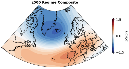
Figure 1. The latest 00z ECMWF Extended Europe weather regime forecast chart.
What Are ECMWF Weather Regimes?
Weather regimes are recurring large-scale atmospheric circulation patterns. In the Euro-Atlantic sector, they describe broad upper-air flow structures that tend to persist for several days or longer. Because these patterns recur and have recognizable downstream impacts, they are especially useful in extended-range forecasting.
The ECMWF weather regimes forecast takes ensemble output and measures how closely the projected atmospheric pattern matches a known circulation regime. Instead of asking only whether one operational run is warmer or colder than normal, regime analysis asks which broader pattern the ensemble is converging toward.
That distinction is important in weeks 2 to 6, when the large-scale pattern is often more predictable than specific day-to-day weather details.

Why ECMWF Weather Regimes Matter for Energy Markets
The main value of the ECMWF weather regimes forecast is that it turns complex ensemble guidance into a more interpretable pattern signal. That is especially useful for energy-market participants who need to understand not just what the model says, but what kind of atmosphere is likely to dominate and how persistent that signal may be.
For traders, utilities, and risk managers, regime analysis can help frame questions such as:
- Is the large-scale pattern becoming more stable or more uncertain?
- Does the forecast favor persistence or a meaningful regime transition?
- Does the pattern support colder demand risk, stronger wind output, or lower solar generation?
- Are recent ECMWF runs reinforcing the same market narrative or reversing it?
That is why weather regimes are valuable in trading-oriented forecasting. They reduce noise and make it easier to communicate weather risk across desks, portfolios, and time horizons.
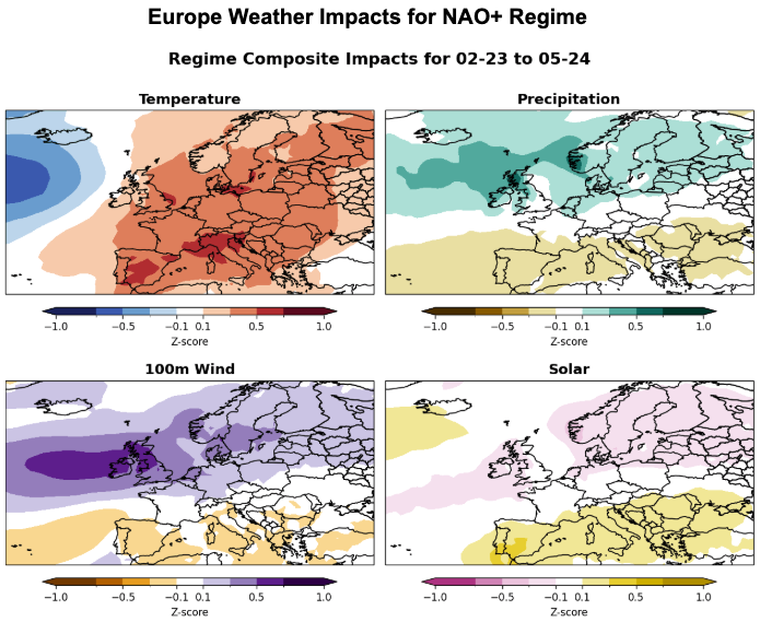
Figure 2. Europe weather regime composite impacts for the NAO+ regime.
How the ECMWF Weather Regimes Forecast Works
At a high level, the ECMWF weather regimes forecast compares forecast atmospheric patterns to a predefined set of recurring large-scale states derived from historical analysis. The idea is that the atmosphere tends to revisit a limited number of preferred circulation configurations rather than evolving through an unlimited number of equally likely patterns.
A simplified workflow looks like this:
- Historical 500 mb geopotential height anomaly data are analyzed to identify recurring circulation patterns.
- Those patterns are grouped into a small number of regimes for a target region such as Europe.
- The ECMWF ensemble forecast is projected into that regime space.
- Each forecast period is assigned probabilities showing how strongly the ensemble supports each regime.
The output is probabilistic, not deterministic. That is what makes the product operationally useful: users can evaluate both the dominant pattern signal and the level of uncertainty surrounding it.
How to Read an ECMWF Weather Regimes Forecast
The best way to read an ECMWF weather regimes chart is to focus on four things: the dominant regime, the probability level, the duration of the signal, and whether the signal is stable from run to run.
1. Identify the dominant regime
Start by finding which regime has the highest probability over the target period. A one-day spike may matter, but a multi-day cluster is usually more meaningful because regime persistence is one of the key reasons this tool is useful in extended-range forecasting.
2. Evaluate the probability spread
If one regime clearly stands above the others, the ECMWF ensemble is showing a more coherent large-scale signal. If several regimes remain close together, confidence is lower and the atmosphere may be in a more transitional or uncertain state.
3. Look for persistence
A regime signal that stays elevated over several consecutive forecast days typically has more operational value than a single short-lived spike. Persistence often matters more than the peak probability on any one day.
4. Watch for transitions
A shift from one dominant regime to another can be highly relevant for market positioning. Regime transitions often precede important changes in temperature anomalies, wind generation, storm tracks, and demand-sensitive risk.
Common Europe Weather Regimes in ECMWF Forecasting
Different classification frameworks exist, but European regime analysis often focuses on a small group of familiar circulation states, including:
- Positive NAO
- Negative NAO
- Atlantic Ridge
- Blocking
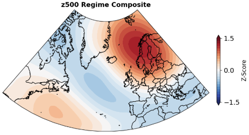
Each regime corresponds to a recognizable upper-air flow structure with typical downstream implications for Europe and surrounding energy markets. While local outcomes still depend on exact pattern placement and amplitude, the regime framework offers a strong first-order view of likely weather risk.
Common North America Weather Regimes in ECMWF Forecasting
Different classification frameworks exist, but North American regime analysis often focuses on a small group of familiar circulation states, including:
- Alaskan Ridge
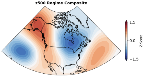
- Greenland High
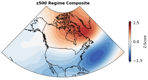
- Pacific Ridge
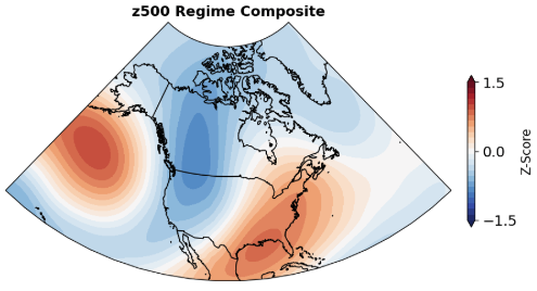
- Pacific Trough
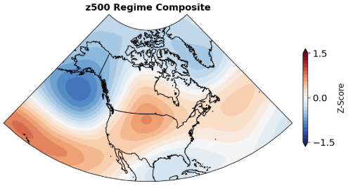
Each regime corresponds to a recognizable upper-air flow structure with typical downstream implications for North America and surrounding energy markets. While local outcomes still depend on exact pattern placement and amplitude, the regime framework offers a strong first-order view of likely weather risk.
Why ECMWF Weather Regimes Work Well in Extended-Range Forecasting
The ECMWF ensemble is widely used for medium-range and subseasonal forecasting because it provides a probabilistic view of atmospheric evolution beyond the short range. Weather regimes complement that framework by translating complex ensemble output into persistent, easier-to-interpret pattern states.
This is particularly useful when:
- Deterministic day-to-day details have low confidence
- Ensemble spread is increasing
- The forecaster needs a coherent large-scale narrative
- The goal is to connect upper-air structure to downstream market impacts
In other words, regime analysis does not replace traditional anomaly maps, plume diagrams, or ensemble products. It improves how those products are interpreted and communicated.

ECMWF Weather Regimes for Energy Traders and Meteorologists
For weather-sensitive trading desks, the value of the ECMWF weather regimes forecast lies in its connection to market-relevant outcomes. A persistent large-scale pattern can influence heating and cooling demand, renewable generation risk, storage expectations, and short-term volatility around shifting weather narratives.
In practice, energy-market users often benefit from asking:
- Does the dominant regime support colder or warmer temperature risk?
- Does the pattern favor stronger or weaker wind generation?
- Is the signal persistent enough to matter for prompt or forward positions?
- Is a transition likely to change the current market weather story?
That is where World Climate Service adds value. Regime analysis becomes most useful when it is integrated with temperature anomalies, wind anomalies, ensemble spread, and market-oriented interpretation rather than used as a standalone label.
ECMWF Weather Regimes vs Raw Ensemble Interpretation
Raw ensemble interpretation remains essential, especially when users need detail, spread, and scenario analysis. But at longer leads, raw ensemble products can become more difficult to summarize cleanly. Weather regime analysis helps organize that uncertainty into a smaller number of recognizable large-scale outcomes.
The two approaches work best together:
- Use ECMWF ensemble products to assess detail and uncertainty
- Use ECMWF weather regimes to interpret the dominant large-scale pattern
- Use both together to evaluate confidence, persistence, and transition risk
Limits of the ECMWF Weather Regimes Forecast
Like any forecast framework, weather regimes have limitations. The methodology is designed to simplify the atmosphere, which makes it useful operationally, but also means some finer-scale detail is lost. Local outcomes still depend on the exact placement and amplitude of the circulation pattern, not only the regime label.
In addition, regime probabilities can weaken or shift quickly if ensemble coherence declines. The right way to use the forecast is as a structured interpretation tool that complements full-model analysis rather than replacing it.
How World Climate Service Uses Weather Regime Forecasts
World Climate Service uses weather regime forecasts to help clients interpret medium-range and subseasonal model guidance in a more structured and decision-oriented way. Regime probabilities make it easier to identify dominant circulation states, monitor transitions, and connect the large-scale pattern to weather-sensitive business risks.
For a broader overview of the methodology and product context, read our guide to weather regime forecasts. That article explains how regime analysis fits into long-range forecasting and trading support more broadly.
If you would like to see how World Climate Service applies regime-based forecasting in an operational environment, contact us to discuss your forecasting workflow and trial options.
Conclusion
The ECMWF weather regimes forecast is useful because it turns complex ensemble output into a smaller set of physically meaningful circulation states. That makes it easier to judge persistence, identify regime transitions, and connect extended-range guidance to real-world energy-market impacts.
For energy traders and meteorologists, the benefit is not just meteorological clarity. It is better decision support. When the large-scale pattern is easier to interpret, weather risk is easier to communicate, monitor, and act on.
Frequently Asked Questions
What is the ECMWF weather regimes forecast?
The ECMWF weather regimes forecast is a probabilistic view of which recurring large-scale circulation patterns the ECMWF ensemble is favoring over future days and weeks. It helps users interpret extended-range guidance through persistent atmospheric states rather than isolated daily maps.
Why are ECMWF weather regimes useful for energy traders?
They help energy traders interpret large-scale weather risk more clearly. Regime probabilities can improve understanding of persistence, transitions, and the likelihood of weather patterns that affect temperature demand, wind output, solar generation, and market volatility.
Are ECMWF weather regimes deterministic?
No. They are probabilistic. The forecast typically shows how strongly the ensemble supports each regime, which allows users to evaluate both the dominant pattern and the degree of uncertainty.
Do weather regimes replace standard ECMWF ensemble analysis?
No. Weather regimes complement standard ensemble analysis. The strongest workflow uses both together: ensemble products for detail and spread, and weather regimes for large-scale structure and persistence.