With the NAO turning negative as we enter an El Niño winter during solar minimum, should Europe expect a repeat of the cold winter of 2009-2010?
Last week the World Climate Service released its updated forecast for the winter months of December through February. While the details of the forecast are restricted to customers at this time, it is interesting to note some similarities – and a few important contrasts – to conditions leading up to the winter of 2009-2010, which was persistently cold in most of Europe.
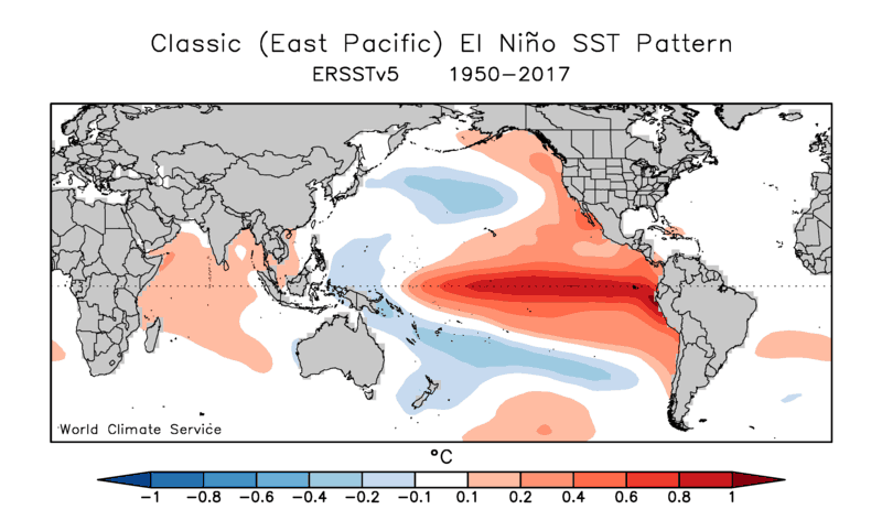
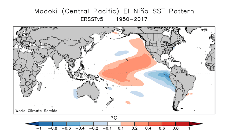
El Niño Modoki
El Niño has been developing in fits and starts for several months, and last month’s Niño3.4 SST anomaly finally exceeded the +0.5°C threshold for El Niño. There is a high probability that at least weak El Niño conditions will persist this winter, but of course not all El Niño events are created equal, either in terms of the phenomenon itself or the impacts on higher latitude weather. The current episode is focused in the west-central equatorial Pacific, making it a “Modoki” pattern, as opposed to the more classical east-based El Niño pattern. The figures below show the typical SST anomaly patterns associated with these contrasting flavors of El Niño.
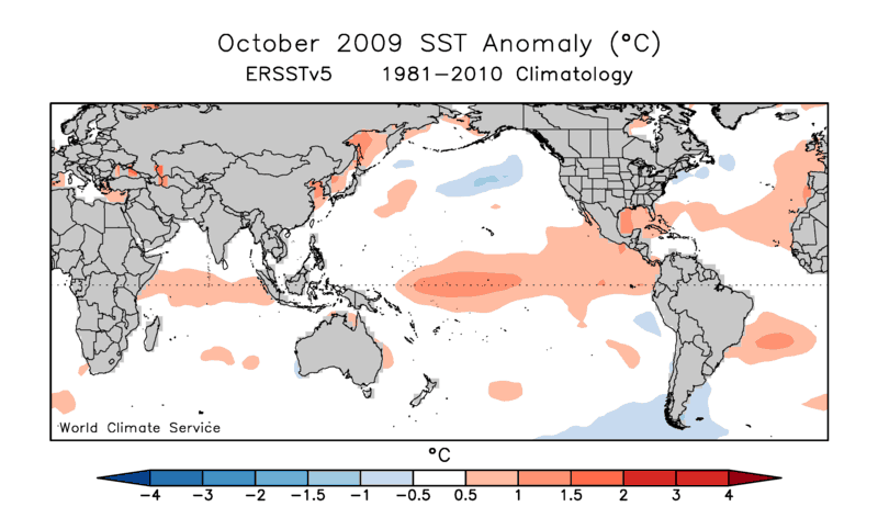
And here’s last month’s SST anomaly map:
The more westward focus of the warmest Niño anomalies makes this event a better match to the 2009-2010 El Niño or the weak episode of 2014-15 than the strong El Niño of 2015-16. In the WCS winter forecast we’ve used the Modoki analog extensively as a baseline for our forecast, but here we’ll just note the similarity of recent tropical conditions to those of 2009.
Solar Minimum
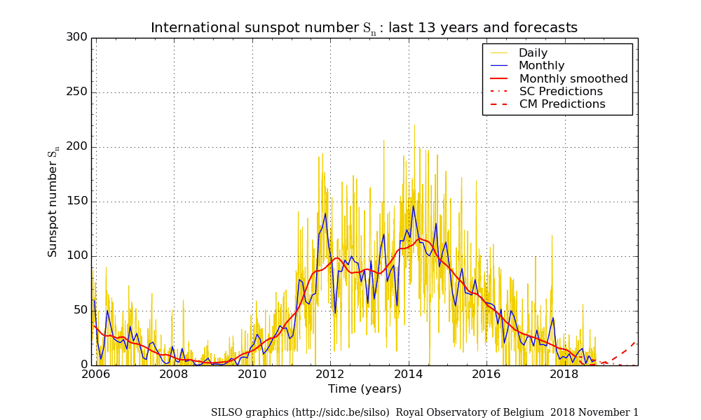
The 11-year solar cycle is drawing quickly to a close as solar minimum approaches, and the sun has been exceptionally quiet in recent months. While there has long been controversy over the impact of the solar cycle on seasonal and global climate, the cold European winters of 2009-10 and 2010-11 revived the notion that North Atlantic pressure patterns can be significantly affected by the solar cycle, because the last solar minimum occurred just prior to those winters. The recent reduction in solar activity therefore seems to be an obvious risk factor for a return to more “blocked” North Atlantic conditions this winter, with consequent cold in Europe.
Emerging Negative NAO
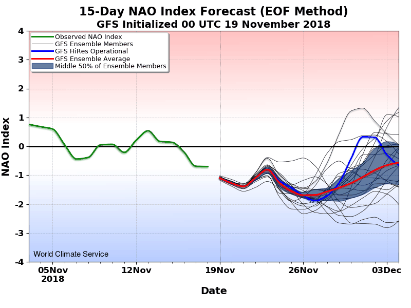
The North Atlantic Oscillation has been very persistently positive since spring of 2018, leading to exceptional warmth and drought in much of central and northern Europe. However, a change is currently unfolding as a remarkably strong ridge over Scandinavia shifts west towards Greenland, inducing a negative NAO phase. In 2009 the NAO shifted into a negative phase right at the end of November after a mild month, and the rest of the winter was spent in a blocked pattern. It remains to be seen whether the current North Atlantic shift is a temporary hiccup in the positive NAO regime, or if this winter resembles the 2009-2010 trajectory. (The WCS winter forecast takes a position on this, and WCS sub-seasonal guidance is already helping refine the outlook for the next month or so.)
Contrary Evidence
While the above factors suggest significant similarities between this winter and that of 2009-10, this is not the end of the story. Notable differences also exist, such as contrasting extratropical SST patterns and differences in stratospheric conditions; for example, the North Pacific is very much warmer than at the same time in 2009, and there is strong westerly flow in the Arctic stratosphere, unlike in November 2009. The Northern Hemisphere circulation anomalies of recent months have also been strikingly different from those of 2009. In response to these differences, some of the World Climate Service statistical guidance does not support a repeat of 2009-10, and indeed a few of the signals show a much different outcome.
Our recently updated winter forecast takes into account all of these considerations along with the latest forecasts from leading dynamical models, some of which suggest increased blocking that would support a colder outlook for Europe. Our experience and historical analysis indicates that some predictors are more reliable than others; for more detail see our in-depth forecast discussion.
Request a World Climate Service trial to read our winter outlook in full.